


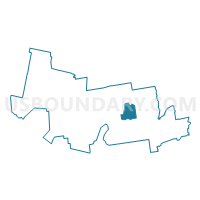
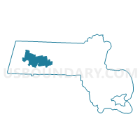
Amherst Precinct 8, Hampshire County, Massachusetts
About
Outline

Summary
| Unique Area Identifier | 594345 |
| Name | Amherst Precinct 8 |
| County | Hampshire County |
| State | Massachusetts |
| Area (square miles) | 10.61 |
| Land Area (square miles) | 10.57 |
| Water Area (square miles) | 0.04 |
| % of Land Area | 99.65 |
| % of Water Area | 0.35 |
| Latitude of the Internal Point | 42.33165130 |
| Longtitude of the Internal Point | -72.49715370 |
Maps

Graphs
Select a template below for downloading or customizing gragh for Amherst Precinct 8, Hampshire County, Massachusetts


Neighbors
Neighoring Voting District (by Name) Neighboring Voting District on the Map
- Amherst Precinct 5, Hampshire County, MA
- Amherst Precinct 6, Hampshire County, MA
- Amherst Precinct 7, Hampshire County, MA
- Belchertown Precinct D, Hampshire County, MA
- Granby Precinct 1, Hampshire County, MA
- Hadley Precinct 1, Hampshire County, MA
- Pelham Precinct 1, Hampshire County, MA
- South Hadley Precinct D, Hampshire County, MA
Top 10 Neighboring County Subdivision (by Population) Neighboring County Subdivision on the Map
- Amherst town, Hampshire County, MA (37,819)
- South Hadley town, Hampshire County, MA (17,514)
- Belchertown town, Hampshire County, MA (14,649)
- Granby town, Hampshire County, MA (6,240)
- Hadley town, Hampshire County, MA (5,250)
- Pelham town, Hampshire County, MA (1,321)
Top 10 Neighboring Place (by Population) Neighboring Place on the Map
Top 10 Neighboring Elementary School District (by Population) Neighboring Elementary School District on the Map
Top 10 Neighboring Secondary School District (by Population) Neighboring Secondary School District on the Map
Top 10 Neighboring Unified School District (by Population) Neighboring Unified School District on the Map
- South Hadley School District, MA (17,514)
- Belchertown School District, MA (14,649)
- Granby School District, MA (6,240)
- Hadley School District, MA (5,250)
Top 10 Neighboring State Legislative District Lower Chamber (by Population) Neighboring State Legislative District Lower Chamber on the Map
- Third Hampshire District, MA (44,059)
- First Franklin District, MA (42,424)
- Second Hampshire District, MA (38,817)
Top 10 Neighboring State Legislative District Upper Chamber (by Population) Neighboring State Legislative District Upper Chamber on the Map
Top 10 Neighboring 111th Congressional District (by Population) Neighboring 111th Congressional District on the Map
Top 10 Neighboring Census Tract (by Population) Neighboring Census Tract on the Map
- Census Tract 8202.03, Hampshire County, MA (8,507)
- Census Tract 8209, Hampshire County, MA (6,240)
- Census Tract 8202.04, Hampshire County, MA (6,142)
- Census Tract 8214, Hampshire County, MA (5,250)
- Census Tract 8208.01, Hampshire County, MA (5,232)
- Census Tract 8207, Hampshire County, MA (4,509)
- Census Tract 8213, Hampshire County, MA (4,197)
- Census Tract 8206, Hampshire County, MA (1,681)
- Census Tract 8202.02, Hampshire County, MA (1,321)
- Census Tract 8208.02, Hampshire County, MA (1,158)